The New Topographical Reality in Saudi Real Estate
For decades, the default approach to masterplanning in Saudi Arabia has been aggressive site grading—flattening natural contours to create uniform, easily parcelled plots. While seemingly straightforward, this traditional method ignores the unique geographical realities of Saudi regions, from Riyadh’s limestone plateaus and dissecting wadis to the steep slopes of Asir and the undulating dunes of the Eastern Province. Today, rising development costs and stringent environmental mandates make this brute-force engineering a major financial liability.
Transitioning toward topography-responsive design is no longer a mere aesthetic preference; it is a commercial imperative driven by modern capital efficiency. By understanding and integrating natural levels and wadi corridors into the masterplan, developers can avoid a costly battle against gravity. Instead, they can leverage natural topography as a key differentiator, creating a unique spatial identity that commands premium pricing and accelerates absorption rates.
The Hidden Cost of 'Flat-Earth' Masterplanning
The financial penalties of ignoring natural topography manifest early in the infrastructure CapEx. When a developer decides to flatten an undulating site, they commit to moving millions of cubic meters of earth and rock, constructing massive concrete retaining walls, and installing complex, energy-intensive artificial stormwater networks to counteract natural gravity. These earthworks not only drain contingency budgets but also extend construction timelines and introduce significant execution risks.
Furthermore, erasing the natural character of the land diminishes its ultimate commercial yield. Monotonous, flattened masterplans result in repetitive urban environments where every plot is identical, lacking the natural vistas, elevated viewpoints, and spatial variety that justify premium pricing. Attempting to force a rigid grid onto complex terrain is a double loss: it inflates development costs while depressing the final land value.
Wadi Integration: Turning Liabilities into High-Value Assets
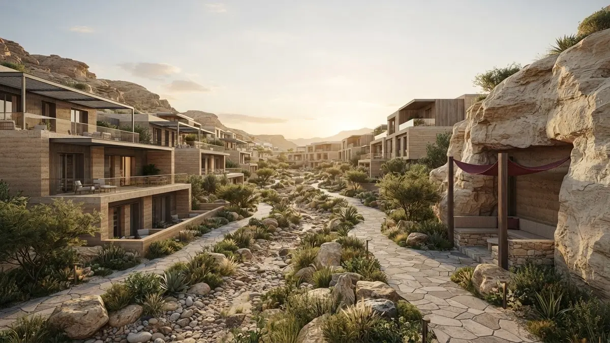
Rather than treating wadi channels as liabilities to be filled or confined within expensive concrete culverts, responsive masterplanning redefines them as high-performing blue and green infrastructure. Integrating natural wadis as linear parks and open recreational corridors achieves two critical goals simultaneously: it secures natural, gravity-fed stormwater drainage paths—eliminating the need for massive subterranean pipe networks—and creates highly desirable green corridors that elevate adjacent land values.
Market performance data indicates that residential and commercial plots fronting integrated wadi parks and natural open spaces command substantial valuation premiums over interior plots. This strategic approach transforms what was once classified as 'unbuildable land' into the primary lifestyle anchor of the development, driving faster sales velocity and maximizing the overall internal rate of return (IRR).
The Technical Framework for Topography-Responsive Design
Transitioning to topography-responsive masterplanning requires a rigorous technical framework that begins with detailed micro-catchment analysis and high-resolution Digital Elevation Models (DEM). Armed with this spatial data, planners align the street network and development parcels with the site's natural contours. This stepped grading approach minimizes earthwork volumes and preserves the natural hydrological flow of the landscape.
The framework also incorporates Sustainable Urban Drainage Systems (SUDs), such as bioswales, rain gardens, and vegetated retention basins. These systems do not just mitigate flash flood risks; they also recharge local aquifers, support native flora, and reduce the urban heat island effect—directly aligning with the ecological objectives of the Saudi Green Initiative.
Regulatory Alignment and Vision 2030 Objectives
This methodology aligns seamlessly with the evolving regulatory landscape in Saudi Arabia. Municipalities and regional development authorities are increasingly enforcing strict codes regarding natural landscape preservation and hydrological safety. Developers who proactively present masterplans respecting natural topography benefit from streamlined municipal approvals, as their designs inherently comply with national safety and environmental mandates.
Moreover, this approach directly supports the Quality of Life Program under Saudi Vision 2030 by creating accessible green networks and shaded pedestrian pathways. Integrating natural geography into the urban fabric of Saudi cities is no longer an afterthought; it is a core benchmark for pioneering developments that aim to shape the future of the Kingdom's built environment.
Self-Qualification and Strategic Next Steps
To determine if your upcoming development requires this strategic approach, consider these qualifying factors: Does your site feature elevation changes exceeding 5%? Are there active or dry wadi channels intersecting your property boundaries? Is the estimated earthworks and retaining wall budget causing concern for your development team? If you answered yes, relying on conventional, flat-grid planning risks exposing your project to severe budget overruns and lengthy regulatory delays.
At Asred, we bridge the gap between commercial viability and responsive physical design. We help you transform complex topographical challenges into high-yielding spatial assets that optimize your CapEx. We invite you to contact our masterplanning team today to schedule a targeted spatial-financial feasibility review of your site, and discover how to unlock the hidden value within your land's natural contours.